Le Viste Diverse D'Italia
The Different Views of Italy
National Capitals

This map was found at Ezilon maps website with the URL: http://www.ezilon.com/maps/images/europe/physical-map-of-Italy.gif.
This map is a fairly extensive map of Italy regarding that highlights mainly fixed landmarks. The major roadways are exemplified and made clear, as well as the distance between and of specific towns are indicated by a color key. In addition to these physical markers, the map also highlights the national capitals of the country with population indicators with varying shapes in the color red. I found an interest in this map because it is one of the few things about Italy that is very clear. I lived in Bologna for one year and found that although Italians may be unclear and vague about many different aspects of life, they are for the most part spatially aware and very cognoscente of their country. The 'national capitals' indicated on with dry clarity on this map encompass many different types of prideful Italians. I enjoy seeing how complex this small country is in map form.
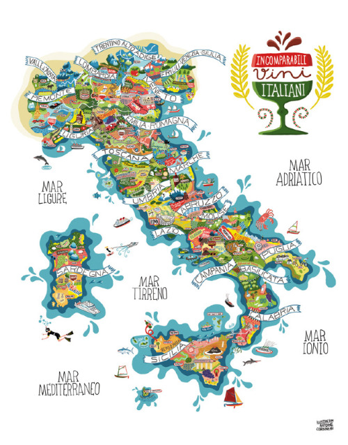
Il Cibo a.k.a. The Food
I found this map on another blog found on Tumblr which is of a map created by Antoine Carbineu and is more of a poster map with the title "Carniato Europe Vini"; with the URL: http://themapsap.tumblr.com/post/7071502401/stunningly-detailed-italy-map-by-antoine.http://www.antoinecorbineau.com/Carniato-Europe-new
The map is a guideline for the different territories of Italy also known as National Capitals but instead of using freeways and spatial distinction between cities, this map highlights one of the things Italy is best known for...it's food. The regions are accurately placed and proportioned and display the different types of foods, activities, and general persona of the people who live in the different regions. I love this map and think it is so fun as well as an accurate portrayal of what each territory is known for. I lived in Bologna, which is in the Emiglia-Romagna region. Is is home to the first University of Italy (one of the oldest in the world) and to a large viticulture region, which describes the pictures of merlot and vineyards in the region. The huge statue in the main piazza of Bologna, Piazza Maggiore is of the Greek God Neptune, which is why there is a picture of Neptune holding a trident, just as he is in Bologna. This map is a fun map, but also very informative, which is why I enjoy it.
I Treni: The Trains
This map was found on the European rail guide website with the URL: http://www.europeanrailguide.com/maps/italy.html.
The map shows the major rail routes through Italy and connecting cities. The routes are differentiated by color and are divided into three different categories. The firs being blue for high-speed rail lines. The second being red for fast inner-city rail lines; and lastly the third being yellow for normal rail lines.
I find this map to be interesting because in Italy, as in most European countries, public transportation is not only normal, but essential to every day life. The high-speed lines are all run by TrenItalia, which is the most reliable line, although generally the trains work amazingly well. It is fascinating to see so clearly how the main line that can run all through Italy can also take you up to Switzerland.
All of these maps show a different aspect to the country of Italy and give off valuable information.


Thanks!
ReplyDeleteI used the Italy map at the top for a school project and it worked great!